

White Lake Celery Flats Restoration Project
Whitehall, MI, Muskegon County, MI
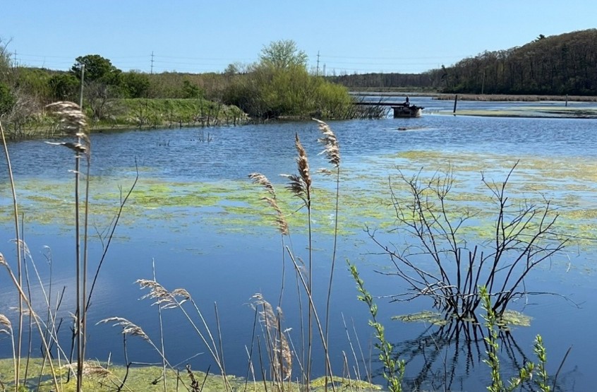
Figure 1. Example berms and pump structures at the Celery Flats Restoration Project site.
The White Lake Celery Flats are a wetland system at the confluence of the White River and White Lake, MI, a drowned river mouth lake flowing into Lake Michigan (See Figures 1 and 2). In the early 1900s, this coastal wetland was diked and drained using large pumps to produce celery and other crops. This conversion to farming disconnected the White River from its floodplain and reduced habitat for fish, birds, and aquatic wildlife, as well as impacted flood storage capacity and flooding in downstream communities.
To begin to address this impairment, the Muskegon Conservation District (MCD), with the City of Whitehall, acquired the 105-acre Hekkema property in 2014 and turned off the dewatering/pumping systems. In 2021, the City of Whitehall acquired the adjacent 63-acre Bishop property completing the transfer of the entire diked system to public ownership. Around that time, a small dike breach caused by high water levels on Lake Michigan/White River flooded both properties (168 acres total), allowing for initial wetland recovery for marsh-spawning fish species, migratory birds, and other wildlife. This project will restore elements of the fish and wildlife community by further enhancing connectivity of the wetlands and the White River and returning ecological function through the reconnection of the floodplain. A project team consisting of MCD, the City of Whitehall, the Michigan Department of Natural Resources (MDNR), the Great Lakes Fishery Commission (GLFC), Michigan State University Extension (MSUE), and Ducks Unlimited (DU) are collaborating to see this restoration project through to completion.
This project will specifically address several regional priorities for improving aquatic habitat. Specifically, habitat will be improved for fish species identified in the Lake Michigan Committee's Environmental Priorities. The environmental priorities addressed include 1) restore/create coastal wetland habitat, naturalize shorelines and increase submerged aquatic vegetation in the southern basin of Lake Michigan to enhance production of lake sturgeon, lake whitefish, yellow perch, and esocids, and 2) restore instream habitat to increase reproductive habitat for fish species of common concern. This project aligns with guiding principles and objectives stated in the LMC's Fish Community Objectives for Lake Michigan to protect and enhance fish habitat, rehabilitate degraded habitats and enhance natural reproduction of native and desirable fishes. The project specifically addresses the State of Michigan's Wildlife Action Plan Conservation ACTIONS for Habitat Land & Water Management H1 and is in a "Priority Area for Conservation Actions" for the State of Michigan. Finally, this project addresses Great Lakes Restoration Initiative Action Plan IV objectives related to improving and sustaining water quality, ecosystem resilience, and native species habitat by enhancing nearshore and coastal wetlands.
Beyond its ecological benefits, this project will strengthen community flood resilience and expand recreational access. Reconnecting the historic river channel and floodplain will increase floodwater storage capacity, helping mitigate localized flooding while opening a previously private, inaccessible stretch of the White River to public kayaking and fishing.
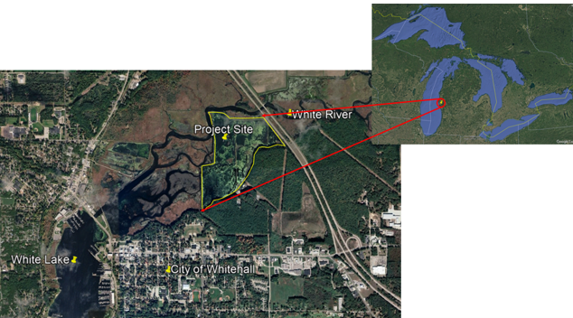
Figure 2. Celery Flats Restoration Project site map (168 acres total).
In 2025, the Great Lakes Fishery Commission provided funding for a feasibility study and design analyzing options for reconnecting the site to the White River, White Lake, and ultimately Lake Michigan. The ongoing study covers three key areas: access to the berms, hydraulic analysis of river flow and floodplain dynamics, and environmental considerations such as fish passage and aquatic habitat. Sediment testing at proposed breach locations found no contamination concerns that would limit construction. Final implementation will focus on breaching of the berms at 8 locations (See Figure 3) to reconnect the floodplain. The berms will be excavated to a depth ensuring connection to the White River even at low water levels. All obsolete dewatering-related infrastructure (electric lines, poles, pipes, buildings, pumps, etc.) will be removed, native wetland plantings will be installed at project completion, and invasive phragmites and shrubs will be targeted for removal by MCD. The ongoing feasibility study and design is at the 60% phase as of October 2026. Completion of the study, design, bid documents, and permitting activities is anticipated by September 2027 with construction work being initiated as early as spring 2028.
Pre-implementation assessment data will be collected focusing on several key areas, including site passability, hydrology, the presence of target fish and waterfowl species, public safety, and community enhancement. Findings from a MDNR Fisheries electrofishing survey, conducted in 2023/2024, will be used in the planning process for fish habitat and species composition with pre- and post-restoration assessments conducted to assess the response of the aquatic community. This property is also surveyed as a partner of the Birds Canada Marsh Monitoring program. All environmental data collected as a part of this project will be provided to the GLFC for posting on the GLFC habitat webpages.
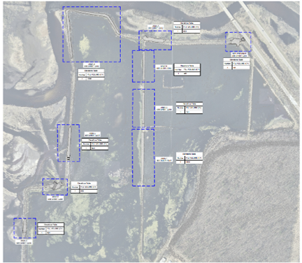
Figure 3. Celery Flats Restoration Project preliminary design berm breech locations (outlined in blue with tentative site access noted on the top right).
MCD and project partners have hosted a series of community engagement and education events in the White Lake area during the feasibility and design process. These events gathered feedback and shared information about the project with residents. Community engagement as a part of design and implementation will continue through various means (public meetings, social media, newsletters, GLFC outreach etc.).
Any physical data collected and models created as a part of the feasibility study, design, and construction will be stored internally by MCD as well as on this website. The data will be available to the public on this website or upon request within 60 days of data validation and entry. All products and data will be available upon request within 2 years of project completion. Contact Jeff Tyson for more information or to make a data request. All future sub-awardees not identified in this plan will be required to adhere to this data sharing plan. Any additional data sharing stipulations for future sub-awardees may be outlined at that time and described in their contract.